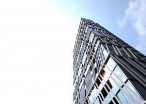
HIGH-RISE PRECINCT: Construction of Blue Earth Group’s Gravity Tower has started in Montague. Picture: PLUS ARCHITECTURE
The southern neighbourhood of Montague will blend modern development with heritage buildings and a network of wide streets and laneways.
New development will reflect the area’s gritty, fine grain urban character. Heritage buildings will be retained and adapted.
A “green spine” running along Buckhurst St will become a focal point for locals, with open space and community facilities connected by pedestrian and cycle links.
New residential developments will complement a vibrant business mix, including home offices and spaces to grow existing creative industries.
A new education and learning facility is planned around a new primary school on Ferrars St. The school is due to open at the start of 2018 and will accommodate 525 students. Planning and site preparation is well underway and the school’s vertical style will be a first for Victoria.
Montague comprises 50ha and is bound by the West Gate Freeway to the north, City Rd to the south, Boundary St and Fishermans Bend to the west and the St Kilda Light Rail Line (Route 96) to the east.
It has a height limit of 40 storeys and is home to Fishermans Bend’s first project to break ground – developer Blue Earth Group’s Gravity Tower, which will have 144 apartments.
Most high rises approved or proposed in Fishermans Bend are in Montague, with no less than seven more towers approved on the same block as Gravity Tower.
It’s not all high-rises, though. Building heights will vary across the precinct to complement the low-rise scale of established residential areas in South and Port Melbourne through to existing tower forms in Southbank and Docklands north of the light rail.
The precinct is named after Montague St, which itself was named after John Montague, 4th Earl of Sandwich and Lord of the Admiralty from 1771 to 1782.
Along with Sandridge and Wirraway, the precinct of Montague is part of the City of Port Phillip.
